|
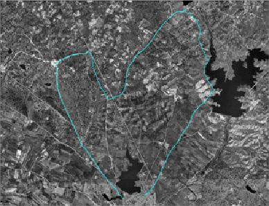
If we follow the urban itinerary of the Arroyo de la Luz Pathway, coming from Brozas by San Marcos bridge, which is in the south of the Charca Grande, we will go through the village and we will take the asphalted road that takes us to the Dehesa de la Luz. Then we will cross the Dehesa partially and we will exit by the access of the Alcántara road, the exact point where we will take the Way to the Valley; After crossing the asphalted road we go through the open fields full of oaks in the Charcas de Petit, a wetland catalogued as Communitary Important Place and integrated in the Red Natura 2000.
From Petit, by the Pelabarguero way, we will go through mounts of oak trees that will take us up to the tail of the reservoir of Molano, well-known as Charca de Molano, dam that stocks drinkable water and also a nice place where to go fishing. From the dam of the reservoir we will go to the village taking the Barcas way that ends in the CV-100 road, recently improved, very close to the municipal cemetery and of the entry of the village from Casar de Cáceres. The route finishes when we arrive to the square and hermitage of San Sebastian, which is a new part of the Arroyo Pathway going through the urban core.
This route is mainly interesting because of the water masses that can be visited, which are fascinating to watch aquatic birds; in addition, the fact of walking along the dehesa is even more attractive, and we can enjoy spending the day there, close to the hermitage.
|
 | Complete
Register Card |  | WayPoints
GPS |  | Map
1:25.0000 |  | Ortophoto
of the route |  | Gallery
of photos |
 | Google
Maps |  | Profile-3D
of the route |  | Digital
Cartography |  | Protected
Areas |  | Points
of the Route |
|
| Technical Card |
Nature
& Culture |
Points of Interest |
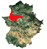
| Municipal Area |
Arroyo de la Luz |
| Beginning of route |
San Marcos Bridge |
| End of Routea |
Hermitage of San Sebastián |
| Suitable dates |
|
| Type of path |
Short (Round) Path |
| Accomplishment |
Path of Small (Circular) Tour |
| Difficulty |
  Low
Low |
| Distance |
14027 meters |
| Duration |
155 minutes
(2:35 horas)
|
| Heights (Min-Max) |
350-382 meters above sea level |
| List of routes and ways |
| - | Arroyo de la Luz Pathway, ways to the hermitage, to Angarilla, to the Valley, to the Cañada, to Pelabarguero and to Barca. |
|
| Cartography |
Topographic National Map
sheets 677 (IV) and 703 (II)
|
| Recommendations |
| - | The Dehesa de la Luz.
| | - | To watch aquatic birds in Molano´s Reservoir.
| | - | To visit Petit´s wetland. |
|
|
|
|